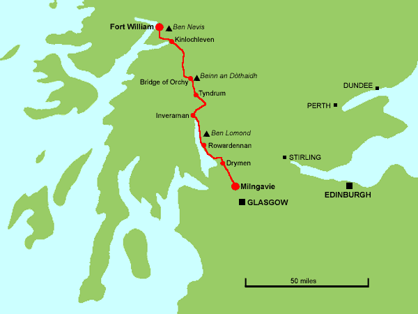
The West Highland Way is a 95-mile (152km) walk from Milngavie, just outside Glasgow, to Fort William on the west coast of Scotland, at the foot of Ben Nevis. I walked the route in September 2001, with a friend, Tim Calow. We made no fixed plans for how far we would walk each day, but aimed to complete the walk in about seven days.
Tim and I travelled separately by train from our respective homes in Skipton and York, and met at Glasgow Central station. From here we used the local trains to reach the start of the walk at Milngavie. Arrival at Milngavie presented us with our first navigational challenge - finding the way out from the station (you go out through the door with the 'ladies' and 'gentlemen' signs). The station is regarded as the unofficial starting point of the West Highland Way, but the official start is from the town square, a short walk from the station.
And so at 12.30 we commenced our 95-mile trek, taking the footpath alongside Allander Water. The route is easy to follow, being waymarked by a thistle-in-hexagon symbol. We paused for lunch just outside Milngavie, then continued through Mugdock Wood.
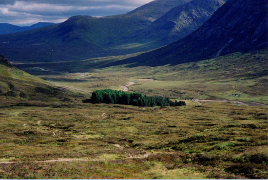
The path heads towards Dumgoyne, a prominent hill at the western edge of the Campsie Fells, then picks up the route of an old railway. In places there are glimpses of the 'real' mountains surrounding Loch Lomond, giving a foretaste of what is to come. We ignored the temptations offered by the Glengoyne Distillery, and shortly afterwards the Beech Tree Inn, and pressed on towards Drymen. On leaving the old railway, there are some stretches of road walking, and shortly before Drymen, at the crest of a hill, we got our first glimpse of Loch Lomond, before dropping down into the village.
We had no pre-booked accommodation, so we called at each place we saw offering Bed & Breakfast. The first two were full, but the proprietor of the second made a phone call to confirm that Mrs Lander in Stirling Road had a twin room free. After a few minutes further walking we were there and able to take off our boots and rest our feet.
We soon found that our host, Frances Lander, enjoyed travelling by train, so I was able to recount some of my journeys. Frances had travelled around Japan by train, and had an ambition to travel on the Trans-Siberian railway to Vladivostok, and to carry on by ship to Japan.
For an evening meal, both Frances and the chap at the second 'no vacancies' had recommended The Clachan, which claims to be Scotland's oldest public house. There, we each had a 3-course meal, my main course being poached salmon. After that, it was early to bed, as it had been a long day.
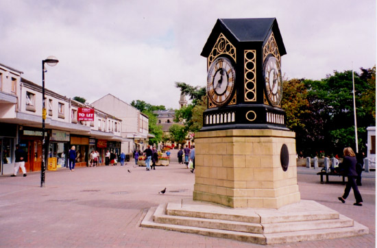 |
The distinctive clock in the town square in Milngavie |
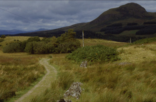 |
The path leading towards Dumgoyne |
We started the day with a hearty cooked breakfast, which included potato scones and oatcakes to give it a Scottish touch. We had decided to head for Rowardennan today, and Frances kindly phoned Danny who runs a B&B there. The house was fully booked but the caravan was available, so we reserved that.
Leaving soon after nine, we regained the West Highland Way just outside the village and headed gently uphill into a forest. I had started out wearing my fleece jacket, but soon had to remove it as it became quite warm in the sunshine.
The path continued for some way along a broad forest track. We met a couple from York who were walking the West Highland Way and were thinking of moving to the area. The path eventually emerged onto open moorland and climbed up Conic Hill, which offered excellent views of Loch Lomond, and to the south we could see the Firth of Clyde.
A steep descent brought us to the lochside village of Balmaha. From here we would follow the eastern shore of the loch until Thursday afternoon.
The last bit of the lochside path was closed because of tree-felling, so the final mile into Rowardennan was along the road. I couldn't remember the name of the B&B (I had written it down but forgotten where), but recognised the name Ben Lomond Cottage when we saw it, and the adjoining caravan was clearly ours. We checked in with Danny, and got settled into the caravan.
We checked the Radio 4 weather forecast for the morning, which said that "North and West Scotland will have plenty of rain", so we dropped thoughts of going up Ben Lomond, and decided that Inverarnan would be our next target.
Food was a high priority for us both, as we hadn't eaten a proper lunch. We walked to the Rowardennan Hotel and each had a filling 3-course meal. I made some phone calls to reserve accommodation for the next night, at the Drovers' Inn.
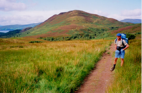 |
The approach to Conic Hill |
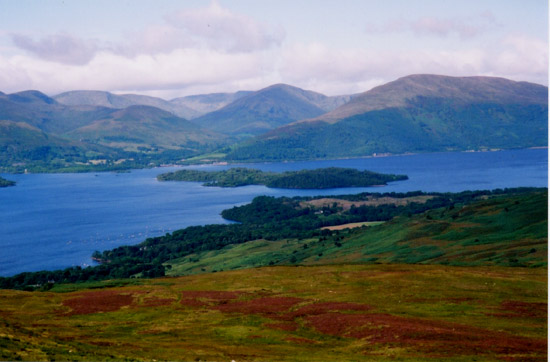 |
Loch Lomond, viewed from Conic Hill |
A good breakfast was provided for us in the main house, where there were 7 other guests, all walking the West Highland Way, including one couple who planned to do it in four days.
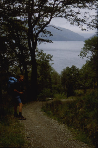
At 9 o'clock we set off. Just north of Rowardennan there are two alternative parallel routes: one at a higher level which follows a broad track through the forest, and a lower path which stays closer to the loch shore. We took the lower one, which twists and turns over boulders, rocky outcrops and tree roots, making progress quite slow, but there were good views of the loch. The weather forecast in the morning had suggested showers in the morning turning to continuous rain in the afternoon, but it stayed fine all morning, and although it was quite cloudy, the sun kept breaking through, shining on the surrounding mountains from time to time.
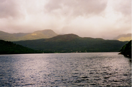
After crossing a footbridge over a burn cascading down from the hills to our right, we arrived at the Inversnaid Hotel. We called in here for a sandwich and a drink, then resumed the walk along the loch shore. Towards its north end, the loch becomes narrower, and noise from the traffic on the A82 Glasgow - Fort William Road was quite noticeable.
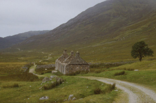
The rain finally arrived later in the afternoon, but by this time we were not far from our destination. We passed the head of the loch, then passed through some woods, where we saw several wild goats. The path descended towards the river, and we branched off from the West Highland Way to cross the river and follow the road to the Drover's Inn.
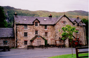
The Drover's is an old coaching inn on the Fort William road. The entrance hall is full of stuffed animals, birds and other assorted junk (or antiques). Our room was in a new accommodation block across the road. This side of the road also had a restaurant (called the Stagger Inn), but we thought this was too formal so we returned to the bar in the old inn, which was crowded. We had a good meal here, including an interesting starter of clapshot and vegetarian haggis. I had no idea what clapshot was, but it turned out to be tatties and neeps. By late evening, most of the original crowd in the bar had left, and there was now a younger crowd who were probably all staying locally. Many of the faces were familiar, as we had seen them at various times in the last couple of days.
 |
North of Rowardennan |
 |
Clouds gather over the northern end of Loch Lomond |
The day started cloudy and damp, and by the time we set out walking at 9.30 a steady drizzle had set in. We began by following the River Falloch upstream, past a series of waterfalls. After a couple of miles of easy walking, the path left the river, crossed under the railway via a 'sheep creep' with very low headroom, and then climbed up the hillside. At the entrance to a forest, a path branched off from the main West Highland Way, and we decided to take this path down into Crianlarich, where we could find some shelter from the rain and a bite to eat.
The path emerged close to the railway station, so it was in the station buffet that we had a lunch of a toasted sandwich and a mug of coffee. It was still raining, so we had a second cup of coffee and a piece of cake before setting out again.
We retraced our steps back into the forest, and came across the group of four ladies that we had seen several times previously over the last few days. We paused for a chat, and found that they were from Staffordshire, and regularly went on walking holidays together. They were staying overnight in Crianlarich, so we left them and headed westwards along the Way, where breaks in the forest offered views both ways along Strath Fillan. The route then dropped down into the valley, crossed the road, the Oban railway and the river, and continued along the north bank most of the way to Tyndrum. By this time, a wind had got up which was driving the rain straight at our faces.
We arrived at the Invervey Hotel in Tyndrum at 5 o'clock, exactly as we had estimated, but dripping wet. There was a drying room for boots and socks, but I found that several things in my rucksack had got damp, so these ended up spread around the bedroom to dry. Fortunately I had enough clean and dry clothes to change into for the evening.
We spent some time planning the next two days walking, which was made more difficult by the scarcity of accommodation over the next part of the Way. The only options directly on the route for the next night were Bridge of Orchy (6 miles), Inveroran (9 miles, and our preferred destination) and King's House (19 miles), and as the hotels at Inveroran and King's House were both full, we ended up making a booking for Bridge of Orchy.
We ate in the hotel bar, where I had haddock and chips for my main course, and also sampled the Oban whisky. It had stopped raining, so we walked to the river bridge where we had entered the village. The sky was clear, and pitch black, allowing a good view of the Milky Way and the relatively unfamiliar summer night sky.
 |
 |
|
The Drover's Inn, Inverarnan |
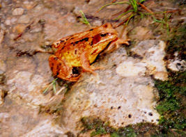
A toad enjoying the rain |
As today's walk was relatively short, we could afford to take our time. We set off after breakfast with damp boots, as the hotel's drying room was not all that warm. We crossed the Fort William railway just outside Tyndrum, and as there was a train due shortly we waited in order to take a photograph of it.
The walking was easy, as the path stays close to the railway all the way to Bridge of Orchy, and apart from a brief shower in the morning, the weather was fine with some sunshine. The railway sweeps around in a 180 degree curve where it crosses a side valley, so we also paused here to photograph a couple of trains.
We arrived at Bridge of Orchy shortly before 3 o'clock and checked into our accommodation, which was in the bunkhouse rather than the main part of the hotel. The bunkhouse had a number of basic but reasonably comfortable triple rooms (one of which we were in) and two dormitories. However, it has since been replaced by more (expensive) hotel rooms. [On subsequent visits to the area, I have stayed at the West Highland Way Sleeper bunkhouse on the station, which I can recommend].
As it was only mid-afternoon, we decided to tackle one of the two mountains which overlook the village. The summits, separated by a col, looked invitingly close, and I was keen to claim my first Munro (Scottish mountain over 3000ft). The appearance was deceptive, and it was a relentlessly steep climb taking us two hours to reach the summit of Beinn an Dòthaidh (1004m, 3294ft). It was worth it though, as there were superb views over Rannoch Moor from the top. [I have since climbed all the Munros, 282 in total]
There is not much to Bridge of Orchy other than the hotel, a post office, a few cottages and the railway station, so it was in the hotel bar where we ate our dinner, a hearty 3-course meal as usual. Again, we recognised several other walkers in the bar, including the Staffordshire Ladies and the German Carpenter's Apprentice.
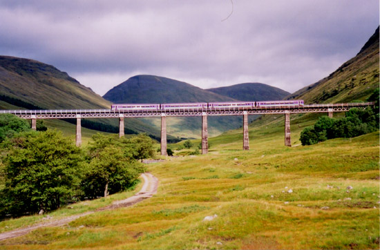 |
The 10.30 Mallaig to Glasgow train crossing the Horseshoe Viaduct between Bridge of Orchy and Tyndrum |
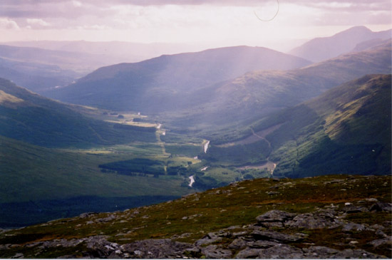 |
The view down Glen Orchy from Beinn an Dòthaidh |
Breakfast for bunkhouse residents was served at 8 in the hotel bar, after which we picked up a packed lunch and set off on the next day of the walk. We did not have any accommodation arranged for the night, and our plan was to walk as far as King's House and then make a decision depending on how we felt. We could carry on to Kinlochleven if we were up to it, or if not we could try the hotel at King's House to see if they had had any cancellations, or we could catch a bus to Glencoe or Ballachulish where there were plenty of hotels and B&Bs.
Today's walk started with a moderate climb out of Bridge of Orchy, and looking back gave us a good view of Beinn an Dòthaidh, which we had climbed the day before. The path then descended to Inveroran, skirted Loch Tulla, and climbed gently along the western edge of Rannoch Moor. It was a clear and sunny day, and we had fine views of Rannoch Moor and the surrounding mountains.
The track, an old military road, eventually began to descend, and on this section we stopped to eat our lunch. We arrived at King's House early in the afternoon, and we were both keen to carry on walking to Kinlochleven, where there were plenty of places to stay, and we estimated that we would reach there by six.
From King's House the West Highland Way initially follows the road (our old friend the A82) in the valley towards the Pass of Glencoe, and then turns right to begin an ascent known as the Devil's Staircase. This is the most strenuous section of the whole walk, as the path climbs steeply in a series of zig-zags to a height of 548m (1798ft). The views looking back were excellent, and when we reached the summit a new vista opened up ahead, dominated by Ben Nevis, with cloud hanging over its summit.
The descent into Kinlochleven was long, and tiring on the feet. One of the first sights approaching the village were the pipelines from the Blackwater Reservoir, then on reaching the village we passed the closed aluminium smelter, which was in the process of being demolished. Our arrival time here was exactly as estimated and we called in at the Tailrace Inn to see if they had any vacancies. They did, so we got settled in, and I found it a great relief to remove my boots and put my feet up.
Downstairs in the bar, we were among previous acquaintances once again. The Dutch Army were here, and we learnt that they were a mobile medical unit (like MASH) doing the walk as a training excercise, but having all their camping gear and luggage transported for them. We had an excellent meal here, and enjoyed a glass of Highland Park (Orkney) whisky as a nightcap.
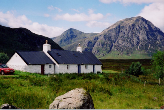 |
Blackrock Cottage, Black Mount, with Buachaille Etive Mór behind |
 |
Looking back towards Altnafeadh from the Devil's Staircase |
The final day's walk began with a steady uphill section through woods, then continued climbing on reaching open moorland. Today was cloudy, and there were a few spots of rain when we were setting off.
The path eventually levelled out and followed the side of a valley, passing some abandoned crofts on the way. After passing through more woods and climbing a bit more, we paused to eat our packed lunch overlooking a steep-sided glen.
The track then descends through more woods, and at a clearing we got a good view of the side of Ben Nevis, the top half of which was blanketed in cloud. The final part of the West Highland Way was a long, gradual descent along a wide track, into Glen Nevis, and then along the roadside into Fort William. This stretch seemed to take forever, and my feet were aching. Eventually, the sign marking the end of the walk, at Nevis Bridge, came into view, and it was all over.
 |
The ruined croft at Tigh-na-sleubhaich |
There is an official West Highland Way website, which has information about the walk, including accommodation, and there is more on the Walking In Scotland website.